OpenLayers Tutorial Part 2: GeoServer
Adding A GeoServer Layer
In our previous tutorial, we created a basic OpenLayers map as an HTML page. In this tutorial, we will overlay the map we created with a layer from GeoServer (usa:states).
Below is the complete application we created in the first tuturial:
<html>
  <head>
    <title>OpenLayers Demo</title>

   <script src="https://cdn.rawgit.com/openlayers/openlayers.github.io/master/en/v5.3.0/build/ol.js"></script>
<link rel="stylesheet" href="https://cdn.rawgit.com/openlayers/openlayers.github.io/master/en/v5.3.0/css/ol.css">


 </head>
  <body>
    <div id="map" class="map"></div>
    <script>

     var layers = [
        new ol.layer.Tile({
          source: new ol.source.OSM()
        })
      ];
      var map = new ol.Map({
        layers: layers,
        target: 'map',
        view: new ol.View({
          center: [-10997148, 4569099],
          zoom: 4
        })
      });
    </script>
  </body>
</html>
Above, we used the following minimal JavaScript code inside the <script> tag to create our map:
var layers = [
        new ol.layer.Tile({
          source: new ol.source.OSM()
        })
      ];
      var map = new ol.Map({
        layers: layers,
        target: 'map',
        view: new ol.View({
          center: [-10997148, 4569099],
          zoom: 4
        })
      });
Adding the GeoServer Layer
To add our GeoServer layer, we simply add the required ol.layer.Image javascript shown below to our existing javascript.
new ol.layer.Image({
          extent: [-13884991, 2870341, -7455066, 6338219],
          source: new ol.source.ImageWMS({

            //Replace 'localhost' below with your server IP or hostname

            url: 'http://localhost/geoserver/wms',
            params: {'LAYERS': 'topp:states'},
            ratio: 1,
            serverType: 'geoserver'
          })
        })
The resulting javascript should now look as below:
 <script>
      var layers = [
        new ol.layer.Tile({
          source: new ol.source.OSM()
        }),
        new ol.layer.Image({
          extent: [-13884991, 2870341, -7455066, 6338219],
          source: new ol.source.ImageWMS({

            //Replace 'localhost' below with your server IP or hostname

            url: 'http://localhost/geoserver/wms',
            params: {'LAYERS': 'topp:states'},
            ratio: 1,
            serverType: 'geoserver'
          })
        })
      ];
      var map = new ol.Map({
        layers: layers,
        target: 'map',
        view: new ol.View({
          center: [-10997148, 4569099],
          zoom: 4
        })
      });
    </script>
Putting It All Together
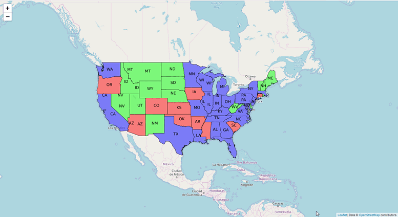
The resulting HTML page should now show our usa:states layer on our map
 <html>
  <head>
    <title>Single Image WMS</title>

   <!-- From https://openlayers.org/en/latest/examples/wms-image.html -->

   <script src="https://cdn.rawgit.com/openlayers/openlayers.github.io/master/en/v5.3.0/build/ol.js"></script>
<link rel="stylesheet" href="https://cdn.rawgit.com/openlayers/openlayers.github.io/master/en/v5.3.0/css/ol.css">


 </head>
  <body>
    <div id="map" class="map"></div>
    <script>
      var layers = [
        new ol.layer.Tile({
          source: new ol.source.OSM()
        }),
        new ol.layer.Image({
          extent: [-13884991, 2870341, -7455066, 6338219],
          source: new ol.source.ImageWMS({

            //Replace 'localhost' below with your server IP or hostname

            url: 'http://localhost/geoserver/wms',
            params: {'LAYERS': 'topp:states'},
            ratio: 1,
            serverType: 'geoserver'
          })
        })
      ];
      var map = new ol.Map({
        layers: layers,
        target: 'map',
        view: new ol.View({
          center: [-10997148, 4569099],
          zoom: 4
        })
      });
    </script>
  </body>
</html>
And our map should now appear as below in your browser: